Ascending to ancient history
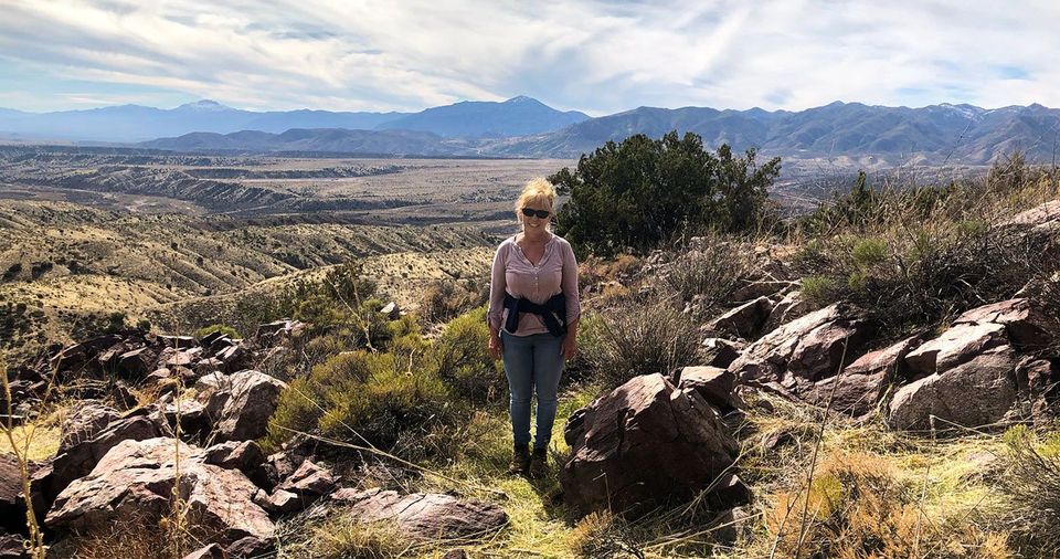
A hike into the unknown, the mysterious and the unexplained describes my thoughts as we reached the top of the summit of 3,971 feet in Gila County, Arizona known to few as Black Mountain. Unlike more popular summits named Black Mountain, such as the mesa of Black Mountain in Pima County and the Black Mountains of Mohave County in Arizona or Black Mountain in Catron County, New Mexico, this Black Mountain is somewhat obscure, primitive, and undeniably off the beaten path, its isolation perhaps being key to preserving the remarkable remains of a prehistoric Arizona.
Mystery question one: Just finding the road leading to Black Mountain is somewhat a mystery to the modern traveler. We see Black Mountain, but where is the road leading to it? Where is the road leading to the ancient mountain ruins once inhabited by Native Americans who established a fortified settlement on the very top of a lone volcanic peak with a full 360-degree view down into the valleys? Where is THAT road???
After locating the vaguely marked primitive road, parking near the entrance at the bottom is a good choice if you are worried about Arizona pin-striping on your vehicle from the desert flora reaching over to greet your truck with a friendly swipe. Although the hike is longer and more arduous, parking here is recommended unless you have an extremely high-based four-wheel drive with exceptionally good shocks, or you love telling four-wheeling adventure stories of narrowly surviving getting to and from your destination. Trust me! We walked up the mountain!
(Another note: Livestock is in the area. If you visit, please be a good wilderness citizen and close the gates as requested.)
Mystery question two: How hard is the hike up Black Mountain? My husband Don and I average walking and hiking four miles a day, but this trail is challenging. The length of the trail we hiked up Black Mountain is approximately one and a half miles UP HILL on a very rocky and slippery path. Challenging but absolutely rewarding!! The excessive effort of hiking to the top is undeniably worth the pain when reaching the top of this volcanic rock summit to stand among the wondrous stone structures created by an ancient civilization.
And the view! As you stand on top of the mountain, among the primordial rocks stacked hundreds of years ago by natives, you witness a breathtaking panorama of the Mazatzals, rising majestically from the desert floor to the west; the valley of Tonto Basin lying to the south, bordered by Mt. Ord and Four Peaks; and the Gisela Road far below winding eastward to Gisela; as you look northward, the magnificence of the Mogollon Rim consumes the horizon. Words do not justly describe the beauty which surrounds you. Glorious! Absolutely glorious!
Also hard to describe is the feeling of being surrounded by remnants of dwellings inhabited hundreds of years ago. What might life have been like? Rocks remain today, selected and stacked very carefully in the formation of rooms and other living spaces by the ancients. One wonders, “What did day-to-day life entail?”
Mystery Question Three: Did the prehistoric natives feel peace on Black Mountain? Or did they fear for their safety? Sitting among the ruins, it is extremely easy to assume they had a very peaceful, quiet, beautiful existence. However, the dwellings were placed strategically on top of a mountain exceedingly difficult to climb, with an outlook in every direction for safety, as if to watch for unwanted intruders. Looking at the structures of the rock foundations, it appears the settlement was rather large with numerous buildings. What was life like for these people? Did time pass slowly? Did time pass fast?
Junipers, cacti, ocotillo, scrub oak, and century plants accent Black Mountain. There are no visible signs of ancient gardening, so one wonders if they were food gatherers, or perhaps hunters, or both. This is perhaps another mystery surrounding these ancient natives; what were their food sources? And who was assigned to be the water carrier? Perhaps they carried water from Rye Creek or Neal Spring. In that case, I do know this: I would NOT have wanted to be assigned to get water! (In my mind, I just cannot let this question go!)
Perhaps, hundreds of years ago, there was a closer, more abundant water source. It’s entirely possible that water flowed more abundantly in this prehistoric era, as evident in the early 1900’s, for at the bottom of Black Mountain stands an old rock dam placed by the United States Forest Service on October 18, 1941 to hold back a reserve of water which has now evaporated. Definitely, an indication of changes over the years, the old rock dam is indeed a sight to see.
A note of caution: Remember where the trail begins down the mountain from the rock structures. It is difficult to locate the trail leading down if you do not mentally note where it is located while coming up. (Thank goodness, Don pays attention to little things like that or I might still be walking around on top of Black Mountain saying, “Is it there?” “Is this it?” “What about here? This looks like the trail going down!”)
If you drove your high-clearance four-wheel drive up the mountain to the turnaround, you will climb Black Mountain and descend only about a half mile on foot; however, if you choose to leave your vehicle as we did at the entrance, you will have a straight downward plunge of a mile and a half on very slippery terrain with rocks and gravel. Good luck and Godspeed!
Experiencing the mysteries of Black Mountain is for those true of heart, who love to hike, explore, and preserve archeological sites. If you visit, please, please leave everything as you find it! From Highway 87, north of Junction 188, turn right onto Gisela Road. Turn left on Forest Service Road 554A. And please remember, this is a very arduous hike; take plenty of water. (You may want to draw straws as to who backpacks the water up the mountain! Remember what I said earlier about water-carrying!) Also, there may be venomous creatures in the area such as rattlesnakes. Please be prepared and be cautious.
In closing, when we first arrived at the bottom of Black Mountain, a hawk flew over us in a ceremonious fashion, representing perhaps a familiar sighting to the Native Americans inhabiting the area many hundreds of years ago. Traveling the rivers of time, the hawk represents courage, strength, wisdom, and clarity. From our family to yours, may hawks fly over you ceremoniously; may your travels be safe and pleasurable; and absolutely, may you not draw the short end of the stick when it comes to carrying water. Blessings!
From scenic overlooks to rivers and wildlife in the White Mountains
Horseback Riding the White Mountain Trail System

Opening home and heart to love again

Kayaks and Crawdads at Big Bear Lake (Sush Be Tou)

Great-Granddaughter of Corydon Cooley

The plight of the cicada

Adventures in Costa Rica part II

The stories we tell ourselves color our responses...

Local White Mountain Artisan and Authur

Are you the voice in your head? or something deeper...